Server time Sat 17/10/2026 at 02:37 | Europe/Rome

1/2 share of agricultural land in Deruta (PG) - LOT 2 (FORMER LOT 5)

Notice
n.33225.2

Real Estate > Land Plots

  • 1/2 share of agricultural land in Deruta (PG) - LOT 2 (FORMER LOT 5) 1
  • Description

AT AUCTION 1/2 share of agricultural land in Deruta (PG), Locality San Nicolò di Celle - OFFERS GATHERING

Co-ownership share equal to an undivided 1/2 of the following real estate assets located in the Municipality of Deruta, Locality San Nicolò di Celle.
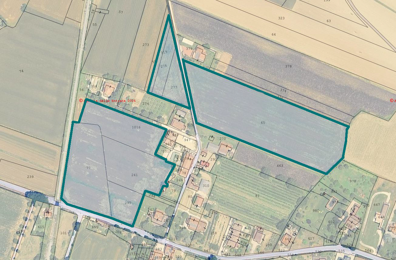
The lot consists of plots of agricultural land divided into three distinct sections, with a total cadastral area of Ha 4.11.34, all classified as level arable land, registered in the Land Registry (Catasto Terreni) of the Municipality of Deruta, Sheet 2.
The three sections are characterized as follows: the first (parcels 319, 276 and 277) is of modest size, regular triangular in shape, with excellent accessibility and good road frontage; the second (parcel 65) is very large, elongated rectangular in shape, with excellent accessibility and road frontage, equipped with a well; the third (parcels 77, 1016, 241 and 295) is very large, regular in shape, with good accessibility and road frontage, burdened by an electricity line easement and bordering the railway line. Along the western boundary of parcel 241 there is a small temporary structure adjoining the building identified by map parcel 79, which is not part of the bankruptcy proceedings. No duly reported well was found on site on map parcel 77.

Occupancy status: all land is vacant, as a result of the termination notices served by the Receiver/Trustee on the company leasing the agricultural land.

Urban planning designation:
According to the current P.R.G. (General Regulatory Plan) of the Municipality of Deruta, the plots fall partly within Agricultural Areas (AA), partly within Areas of Particular Agricultural Interest (APIA) and partly within zone B1 – consolidated fabrics and areas predominantly residential to be maintained at low density (arts. 28-33 of the N.T.A.). The adopted P.R.G.P.O. provides for the classification "IPRE 01" – Existing Predominantly Residential Settlements (art. 94 RR 2/2015). Approval of implementing urban planning instruments is not required for use. The area is declared a seismic zone pursuant to Law 64/74; it falls within stable zones susceptible to local amplification (cat. 6 – valley-bottom areas with alluvial deposits); it is served by existing water network and sewers; part is affected by historic road network and by Sheet 9R 66 Perugia DM 10/05/1957 (Giardini Carducci). This urban planning information is certified by the Certificate of Urban Planning Designation no. 6219/2026 issued by the Municipality of Deruta on 17 April 2026, valid for one year from the date of issue.

Land Registry (Catasto Terreni) of the Municipality of Deruta, Sheet 2:
Parcel 319 - Type: Arborated arable land - Class 1 - Area 730 sqm - R.D. € 4,52 - R.A. € 3,77
Parcel 276 - Type: Arable land - Class 1 - Area 1.400 sqm - R.D. € 8,68 - R.A. € 7,59
Parcel 277 - Type: Arable land - Class 1 - Area 1.780 sqm - R.D. € 11,03- R.A. € 9,65
Parcel 65 - Type: Arborated arable land - Class 1 - Area 18.035 sqm - R.D. € 111,77 - R.A € 93,14
Parcel 77 - Type: Arborated arable land - Class 1 - Area 7.070 sqm - R.D. € 43,82 - R.A. € 36,51
Parcel 1016 - Type: Arborated arable land - Class 1 - Area 4.631 sqm - R.D. € 28,70 - R.A. € 23,92
Parcel 241 - Portion AA - Type: Arable land - Class 1 - Area 5.210 sqm- R.D. € 32,29 - R.A. € 28,25
Parcel 241 - Portion AB - Type: Vineyard - Class 2 - Area 110 sqm - R.D. € 0,60 - R.A. € 0,54
Parcel 295 - Type: Arborated arable land - Class 1 - Area 2.168 sqm - R.D. € 13,44 - R.A. € 11,20

For further information, please consult the appraisal report and the attached documentation

Road access: Yes

Area: 5.090 sqm

Foglio: 2

Particella: 319

Free: Yes

Lot Code: 2

  • Attached documents (6)

€
 Offers:

Suspended Lot for

Buyer's Premium see specific conditions

sold

Request more info Request viewing General Terms Specific Terms PVP data
ID Inserzione4642413
e4e46591-c258-11f1-b0b5-0a586443160d
Procedura
Tipologiagiudiziaria
ID Procedura722079
Tipo Proceduragiudiziaria
ID Tribunale0540390094
ID RitoNFAL
ID RegistroPROCEDURE_CONCORSUALI
TribunaleTribunale di PERUGIA
RegistroPROCEDURE CONCORSUALI
RitoFALLIMENTARE (NUOVO RITO)
Num.Procedura41
Anno Procedura2021
Soggetti
  • Soggetto
    TipoSoggetto specializzato alla vendita
    Nome
    CognomeGobid international auction group srl
    Cod.Fisc.GRGNDR67A25H211F
    Email[email protected]
    Telefono0286882269
    ID Anagrafica5598370
    Soggetto VenditaSí1
    Soggetto VisitaSí1
Lotto
ID Lotto2495466
Descrizione (IT)RACCOLTA OFFERTE - Quota 1/2 di terreni agricoli a Deruta (PG), Località San Nicolò di Celle - LOTTO 2 (EX LOTTO 5) - vendita telematica sulla piattaforma www.gobidreal.it n.33225.2
Primo Identificativo2495466
Codice2
GenereIMMOBILI
CategoriaALTRA CATEGORIA
IndirizzoLocalità San Nicolò di Celle
ComuneDeruta
ProvinciaPerugia
RegioneUmbria
NazioneItalia
Beni
  • Bene
    ID Bene3212509
    Descrizione (IT)Quota di comproprietà pari ad 1/2 indiviso sui seguenti beni immobili siti nel Comune di Deruta, Località San Nicolò di Celle. Il lotto è composto da appezzamenti di terreno agricolo suddivisi in tre corpi distinti, per una consistenza catastale totale di Ha 4.11.34, tutti qualificati come seminativi pianeggianti, censiti al Catasto Terreni del Comune di Deruta, Foglio 2. I tre corpi si caratterizzano come segue: il primo (p.lle 319, 276 e 277) è di modesta estensione, di forma triangolare regolare, con ottima accessibilità e buon fronte strada; il secondo (p.lla 65) è molto ampio, di forma rettangolare allungata, con ottima accessibilità e fronte strada, dotato di pozzo; il terzo (p.lle 77, 1016, 241 e 295) è molto ampio, di forma regolare, con buona accessibilità e fronte strada, gravato da servitù di elettrodotto e posto a confine con la linea ferroviaria. Sul confine ovest della p.lla 241 è presente una piccola struttura precaria in aderenza al fabbricato di cui al mappale 79, estraneo alla procedura fallimentare. Non è stato riscontrato in loco un pozzo regolarmente denunciato sul mappale 77. Stato di possesso: tutti i terreni sono liberi, per effetto delle disdette effettuate dalla Curatela nei confronti della società conduttrice dei fondi agricoli. Destinazione urbanistica:  Secondo il P.R.G. vigente del Comune di Deruta, gli appezzamenti ricadono in parte in Aree Agricole (AA), in parte in Aree di Particolare Interesse Agricolo (APIA) e in parte in zona B1 – Tessuti e ambiti consolidati prevalentemente residenziali a mantenimento a densità bassa (artt. 28-33 delle N.T.A.). Il P.R.G.P.O. adottato prevede la classificazione "IPRE 01" – Insediamenti Prevalentemente Residenziali Esistenti (art. 94 RR 2/2015). Non è richiesta l'approvazione di strumenti urbanistici attuativi per l'utilizzazione. L'area è dichiarata zona sismica ai sensi della L. 64/74; è ricompresa in zone stabili suscettibili di amplificazioni locali (cat. 6 – aree di fondovalle con depositi alluvionali); è interessata da rete idrica esistente e fognature; parte è interessata da viabilità storica e dalla Scheda 9R 66 Perugia DM 10/05/1957 (Giardini Carducci). Il presente dato urbanistico è attestato dal Certificato di Destinazione Urbanistica n. 6219/2026 rilasciato dal Comune di Deruta in data 17 aprile 2026, valido un anno dalla data di rilascio. Catasto Terreni del Comune di Deruta al Foglio 2: Particella 319 - Qualità Seminativo arborato - Classe 1 - Superficie 730 mq - R.D. € 4,52 - R.A. € 3,77; Particella 276 - Qualità Seminativo - Classe 1 - Superficie 1.400 mq - R.D. € 8,68 - R.A. € 7,59; Particella 277 - Qualità Seminativo - Classe 1 - Superficie 1.780 mq - R.D. € 11,03- R.A. € 9,65; Particella 65 - Qualità Seminativo arborato - Classe 1 - Superficie 18.035 mq - R.D. € 111,77 - R.A € 93,14; Particella 77 - Qualità Seminativo arborato - Classe 1 - Superficie 7.070 mq - R.D. € 43,82 - R.A. € 36,51; Particella 1016 - Qualità Seminativo arborato - Classe 1 - Superficie 4.631 mq - R.D. € 28,70 - R.A. € 23,92; Particella 241 - Porzione AA - Qualità Seminativo - Classe 1 - Superficie 5.210 mq- R.D. € 32,29 - R.A. € 28,25; Particella 241 - Porzione AB - Qualità Vigneto - Classe 2 - Superficie 110 mq - R.D. € 0,60 - R.A. € 0,54; Particella 295 - Qualità Seminativo arborato - Classe 1 - Superficie 2.168 mq - R.D. € 13,44 - R.A. € 11,20
    Primo Identificativo3212509
    TipologiaALTRA CATEGORIA
    CategoriaTERRENO
    IndirizzoLocalità San Nicolò di Celle
    ComuneDeruta
    ProvinciaPerugia
    RegioneUmbria
    NazioneItalia
    Bene Immobile
    • Dati catastali
      Foglio/
      Particella/
    Tipo DenunciaProtocollo
Dati Vendita
Data e oraFri 20 November 2026 at 12:012026-11-20T12:01:00
TipologiaCOMPETITIVA
ModalitàPRESSO IL VENDITORE
Indirizzovendita telematica sulla piattaforma www.gobidreal.it
CAP20148
ComuneMilano
ProvinciaMilano
RegioneLombardia
NazioneItalia
Prezzo base42.320,00
Offerta Minima42.320,00
Rialzo Minimo1.000,00
Termine Presentazione OfferteFri 20 November 2026 at 12:002026-11-20T12:00:00
Siti
  • Sito
    ID22
    Tipologiasito pubblicita
    Nominativohttps://www.gobidreal.it/
    Indirizzo URLhttps://www.gobidreal.it/
Data pubblicazione07/10/20262026-10-07

Related lots

Need help?